EXECUTIVE SUMMARY
WHAT IS THE MONTANA CLIMATE ASSESSMENT?
The Montana Climate Assessment (MCA) is an effort to synthesize, evaluate, and share credible and relevant scientific information about climate change in Montana with the citizens of the State. The motivation for the MCA arose from citizens and organizations in Montana who have expressed interest in receiving timely and pertinent information about climate change, including information about historical variability, past trends, and projections of future impacts as they relate to topics of economic concern. This first assessment reports on climate trends and their consequences for three of Montana’s vital sectors: water, forests, and agriculture. We consider the MCA to be a sustained effort. We plan to regularly incorporate new scientific information, cover other topics important to the people of Montana, and address the needs of the state.
The process to develop the first MCA was driven by stakeholder input and informed by the best-available science. Insights regarding topics to cover were developed from questionnaires, conversations, and listening sessions held across the state. A team of researchers, educators, and stakeholders used that feedback to select the topics covered.
The Montana Institute on Ecosystems, a statewide center based at both Montana State University and University of Montana, has taken on the responsibility of organizing the MCA. The 2017 MCA is the result of two years of work by university faculty and students, state and federal agency researchers, non-profit organizations, resource managers, and citizens from across Montana.
The assessment begins with an analysis of Montana’s recent climate trends and how climate is projected to change in the future (Chapter 2). This information is used throughout the assessment to explain the key impacts of climate change observed in recent decades and projected in the future. Discussion of climate change impacts on Montana’s water (Chapter 3), forests (Chapter 4), and agriculture (Chapter 5) are presented next. The assessment concludes with an analysis of major knowledge gaps—and thus areas for future research—related to climate change and its impacts on the three sectors covered herein (Chapter 6).
MONTANA’S CLIMATE
Understanding current climate change and projecting future climate trends is of vital importance, both for our economy and our well-being. The Climate chapter serves as a foundation for the MCA, providing information on present-day climate as well as climate terminology, past climate trends, and future climate projections. The chapter is an introduction to climate science and the important processes that determine whether climate remains constant or changes.
Climate basics
Climate is driven largely by energy from the sun, and the manner in which this incoming solar radiation is reflected, absorbed, transformed (as in photosynthesis), or re-radiated (as heat). Each of these processes influences climate through changes to temperature, the hydrologic cycle, vegetation, and atmospheric and ocean circulation patterns. Climate change, as defined by the US Global Change Research Program (USGCRP undated), includes:
Changes in average weather conditions that persist over multiple decades or longer. Climate change encompasses both increases and decreases in temperature, as well as shifts in precipitation, changing risk of certain types of severe weather events, and changes to other features of the climate system.
Such changes are driven in large part by the greenhouse effect, the trapping of greenhouse gases in Earth’s atmosphere and consequent warming of the planet. The rapid rate of climate change since the Industrial Revolution has resulted from changes in atmospheric chemistry, specifically increases in greenhouse gases due to increased combustion of fossil fuels, land-use change (e.g., deforestation), and fertilizer production (Forster et al. 2007). The primary greenhouse gases in the Earth’s atmosphere are carbon dioxide (CO2), methane (CH4), nitrous oxide (N2O), water vapor (H2O), and ozone (O3).
Montana’s unique features
To understand climate change in Montana, we must first understand Montana’s unique geography. Montana is the fourth largest state in the nation and its location within North America exposes the state to a mix of diverse weather systems that originate from the Pacific Ocean, the Arctic, and sometimes subtropical regions. The Continental Divide, which has a predominantly north-south alignment in Montana, effectively splits the state into climatically distinct western wet and eastern dry regions with respect to moisture from eastward-flowing Pacific Maritime air. The state also includes the beginnings of three major river basins—the Missouri, Snake/Columbia, and Saskatchewan—two of which encompass almost one-third of the landmass of the conterminous United States. Consequently, Montana’s climate influences the water supply of a large portion of the country, and its water supports communities, ecosystems, and economies far beyond its borders.
Our analysis
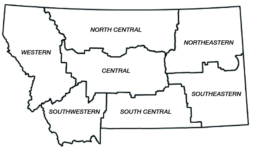
Montana’s unique geography means that climate varies across the state, as it does across the nation. Throughout the MCA, we aggregate past climate trends and future climate projections into seven Montana climate divisions, as shown in Figure I. These seven climate divisions are a subset of the 344 divisions defined by the National Oceanic and Atmospheric Administration (NOAA) based on a combination of climatic, political, agricultural, and watershed boundaries (NOAA undated).
|
|
| Figure I. Montana’s seven climate divisions. |
To assess Montana’s historical climate, we evaluated temperature and precipitation trends since the mid-20th century by using standard statistical methods to analyze records of temperature and precipitation. To assess future projected changes to Montana’s climate, we employed an ensemble of climate models from the fifth iteration of the Coupled Model Intercomparison Project (CMIP5), and utilized a statistically downscaled dataset.
Major findings
The results of this analysis produced several key messages, some of which are shown below, about Montana’s historical and future climate (for a complete list of key messages, see the Climate chapter):
|
|
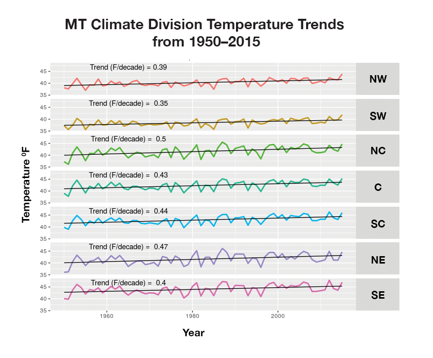
| Figure II. Trends in annual average temperature across each climate division (Figure I) in Montana. The divisions are northwestern (NW), southwestern (SW), north central (NC), central (C), south central (SC), northeastern (NE), and southeastern (SE). |
Mid-century and End-of-century |
 |
|
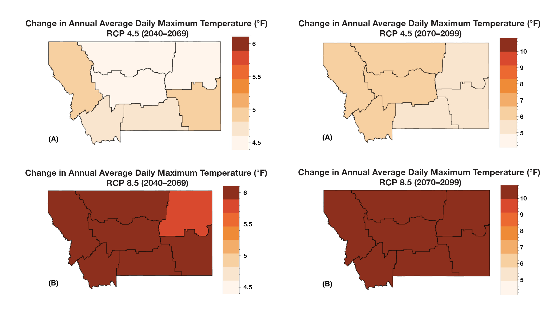
Figure III. The projected increase in annual average daily maximum temperature (°F) for each climate division in Montana for the periods 2049-2069 and 2070-2099 for (A) stabilization (RCP4.5) and (B) business-as-usual (RCP8.5) emission scenarios. |
- Annual average temperatures, including daily minimums, maximums, and averages, have risen across the state between 1950 and 2015. The increases range between 2.0-3.0°F (1.1-1.7°C) during this period (see Figure II). [high agreement, robust evidence]1
- Despite no historical changes in average annual precipitation between 1950 and 2015, there have been changes in average seasonal precipitation over the same period. Average winter precipitation decreased by 0.9 inches (2.3 cm), which can largely be attributed to natural variability and an increase in El Niño events, especially in the western and central parts of the state. A significant increase in spring precipitation (1.3-2.0 inches [3.3-5.1 cm]) also occurred during this period for the eastern part of the state. [moderate agreement, robust evidence]
- Montana is projected to continue to warm in all geographic locations, seasons, and under all emission scenarios throughout the 21st century. By mid century, Montana temperatures are projected to increase by approximately 4.5-6.0°F (2.5-3.3°C) depending on the emission scenario. By the end-of-century, Montana temperatures are projected to increase 5.6-9.8°F (3.1-5.4°C) depending on the emission scenario. These state-level changes are larger than the average changes projected globally and nationally (Figure III). [high agreement, robust evidence]
- Across the state, precipitation is projected to increase in winter, spring, and fall; precipitation is projected to decrease in summer. The largest increases are expected to occur during spring in the southern part of the state. The largest decreases are expected to occur during summer in the central and southern parts of the state. [moderate agreement, moderate evidence]
Table I provides a summary of climate metrics developed under the MCA.
| Climate Metric— | Trend and future scenario |
| Atmospheric CO2 concentrations | Global atmospheric carbon dioxide concentrations have increased over 100 ppm since Montana statehood and are projected to increase under both future scenarios considered here. |
| Average temperature | Since 1950, average statewide temperatures have increased by 0.5°F/decade (0.3°C/decade), with greatest warming in spring; projected to increase by 3-7°F (1.7-3.9°C) by mid century, with greatest warming in summer and winter and in the southeast. |
| Maximum temperatures | Maximum temperatures have increased most in spring and are projected to increase 3-8°F (1.7-4.4°C) by mid century, with greatest increases in August and in the southeast. |
| Days above 90°F (32°C) | Extreme heat days are projected to increase by 5-35 additional days by mid century, with greatest increases in the northeast and south. |
| Minimum temperatures | Minimum temperatures have increased most in winter and spring and are projected to increase 3-7°F (1.7-3.9°C) by mid century, with greatest increases in January and in the southeast. |
| Frost-free days | Frost-free days are projected to increase by 24-44 days by mid century, particularly in the west. |
| Average precipitation | Statewide precipitation has decreased in winter ( 0.14 inches/decade [-0.36 cm/decade]) since 1950, but no significant change has occurred in annual mean precipitation, probably because of very slight increases in spring and fall precipitation. Precipitation is projected to increase, primarily in spring (0.2-0.7 inches [0.5-1.8 cm]) in the northwest; a slight statewide decrease in summer precipitation and increased year-to-year variability of precipitation are projected, as well. |
| Number of consecutive dry days | Little projected change, with a maximum increase of 3 days to -3 days under the most severe scenario by end of the century. However, increased variability in precipitation suggests potential for more severe droughts, particularly in connection with climate oscillations. |
| Number of consecutive wet days | No substantial change projected. |
IMPACTS TO MONTANA’S WATER
Water in Montana
Montana depends on an adequate supply of clean water for nearly every aspect of our economy, including food production, hydroelectric power, domestic and industrial uses, and sustaining our natural ecosystems. The vast majority of water that enters Montana comes as rain or snow at higher elevations (MT DNRC 2014a, b, c, d; MT DNRC 2015). Although some of Montana’s water originates in Wyoming or adjacent Canadian provinces, over 80% is derived from within state boundaries, hence Montana’s designation as a “headwaters state.” The major rivers of Montana export more than 40 million acre-feet of water/yr (4.9x10¹⁰ m3/yr)2 —more than twice the capacity of Flathead Lake—with the majority, approximately 60%, generated in the Clark Fork and Kootenai river basins west of the Continental Divide.
Groundwater is another large and important component of the water cycle in Montana, with most groundwater coming from shallow sand or gravel aquifers in river floodplains. Groundwater resources are critical for water users, but also contribute significantly to natural streamflow throughout the year. In Montana, much of the winter snowfall that accumulates in the mountains melts in spring to produce streamflow and recharge groundwater aquifers. Projected changes in temperature will have large effects on how water enters Montana (e.g., as rain or snow), how it is distributed among major storage pools, and how it moves or changes from one component of the water cycle to another.
Our analysis
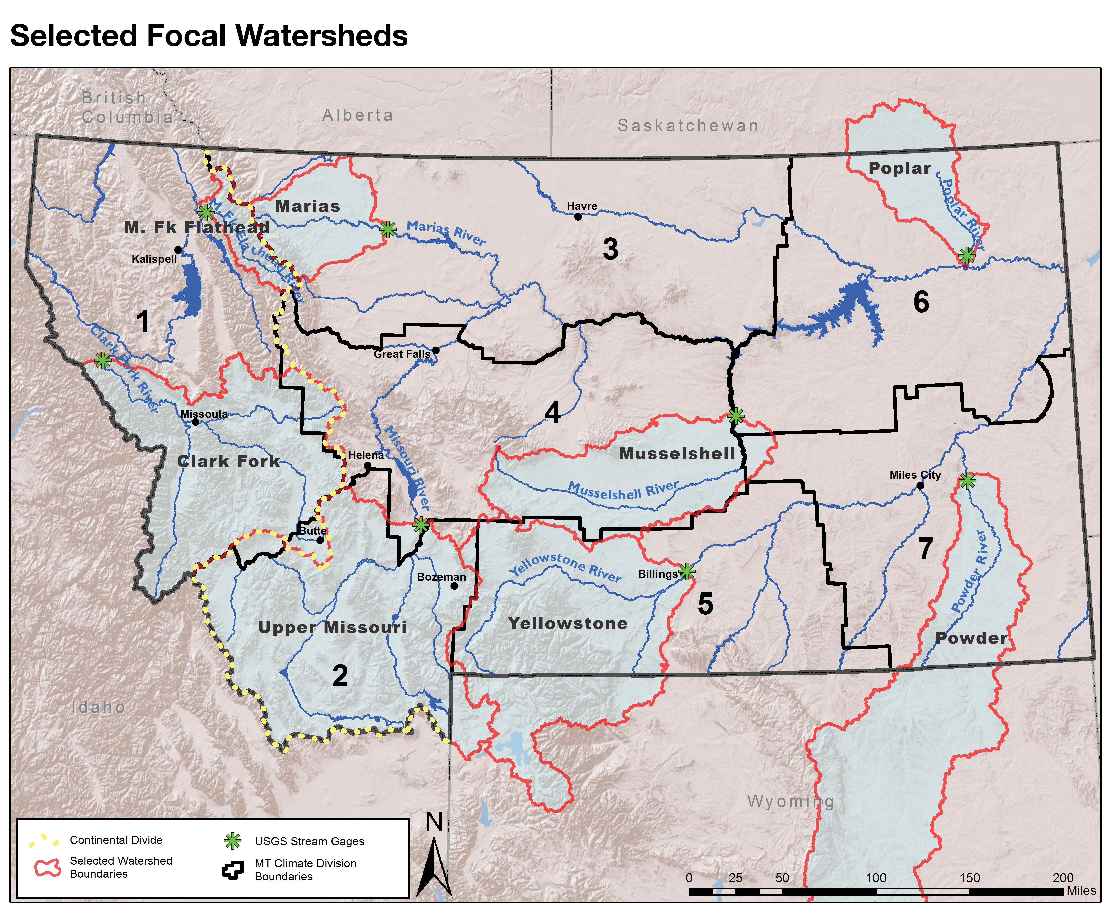
To best represent the influence of climate variations on water resources, the Water chapter focuses on eight rivers and their watersheds (Figure IV; note that some watersheds—for example, that of Poplar River—extend beyond the state boundaries). These focal rivers and watersheds, chosen across the state’s seven NOAA climate divisions,3 include:
- Climate division 1
—Clark Fork River at Saint Regis
—Middle Fork of the Flathead River at West Glacier - Climate division 2—Missouri River at Toston
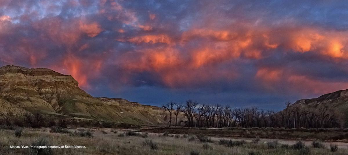
- Climate division 3—Marias River near Shelby
- Climate division 4—Musselshell River at Mosby
- Climate division 5—Yellowstone River at Billings
- Climate division 6—Poplar River near Poplar
- Climate division 7—Powder River near Locate
|
|
| Figure IV. The focal rivers for this assessment, including black outlines of the seven climate divisions (see Water chapter), contributing watersheds (red), river gage locations (green), and the Continental Divide (dotted). |
Complex computer models (see Climate chapter) provide a method for projecting future climate scenarios in Montana. By linking climate models to water-cycle models, we generate projections about how climate change is likely to influence water resources. For the projections in the Water chapter, we present results from as many as 31 climate models that are linked to a water-cycle model. We utilize these projections to discuss how climate change may affect key components of the water cycle, including:
- Snowpack
- Snowmelt runoff and timing
- Annual streamflow
- Groundwater resources
- Drought
Major findings
The results of this analysis produced several key messages, some of which are shown below, about how climate change will affect Montana’s water resources (for a complete list of key messages, see the Water chapter).
Rising temperatures will reduce snowpack, shift historical patterns of streamflow in Montana, and likely result in additional stress on Montana’s water supply, particularly during summer and early fall. Key messages associated with these findings follow:
- Montana’s snowpack has declined over the observational record (i.e., since the 1930s) in mountains west and east of the Continental Divide; this decline has been most pronounced since the 1980s. [high agreement, medium evidence]
- Warming temperatures over the next century, especially during spring, are likely to reduce snowpack at mid and low elevations. [high agreement, robust evidence]
- Historical observations show a shift toward earlier snowmelt and an earlier peak in spring runoff in the Mountain West (including Montana). Projections suggest that these patterns are very likely to continue into the future as temperatures increase. [high agreement, robust evidence]
- Earlier onset of snowmelt and spring runoff will reduce late-summer water availability in snowmelt-dominated watersheds. [high agreement, robust evidence]
- Groundwater demand will likely increase as elevated temperatures and changing seasonal availability of traditional surface-water sources (e.g., dry stock water ponds or inability of canal systems to deliver water in a timely manner) force water users to seek alternatives. [high agreement, medium evidence]
Rising temperatures will exacerbate persistent drought periods that are a natural part of Montana’s climate. Key messages associated with these findings follow:
- Multi-year and decadal-scale droughts have been, and will continue to be, a natural feature of Montana’s climate [high agreement, robust evidence]; rising temperatures will likely exacerbate drought when and where it occurs. [high agreement, medium evidence]
- Changes in snowpack and runoff timing will likely increase the frequency and duration of drought during late summer and early fall. [high agreement, medium evidence]
IMPACTS TO MONTANA’S FORESTS
Forests in Montana
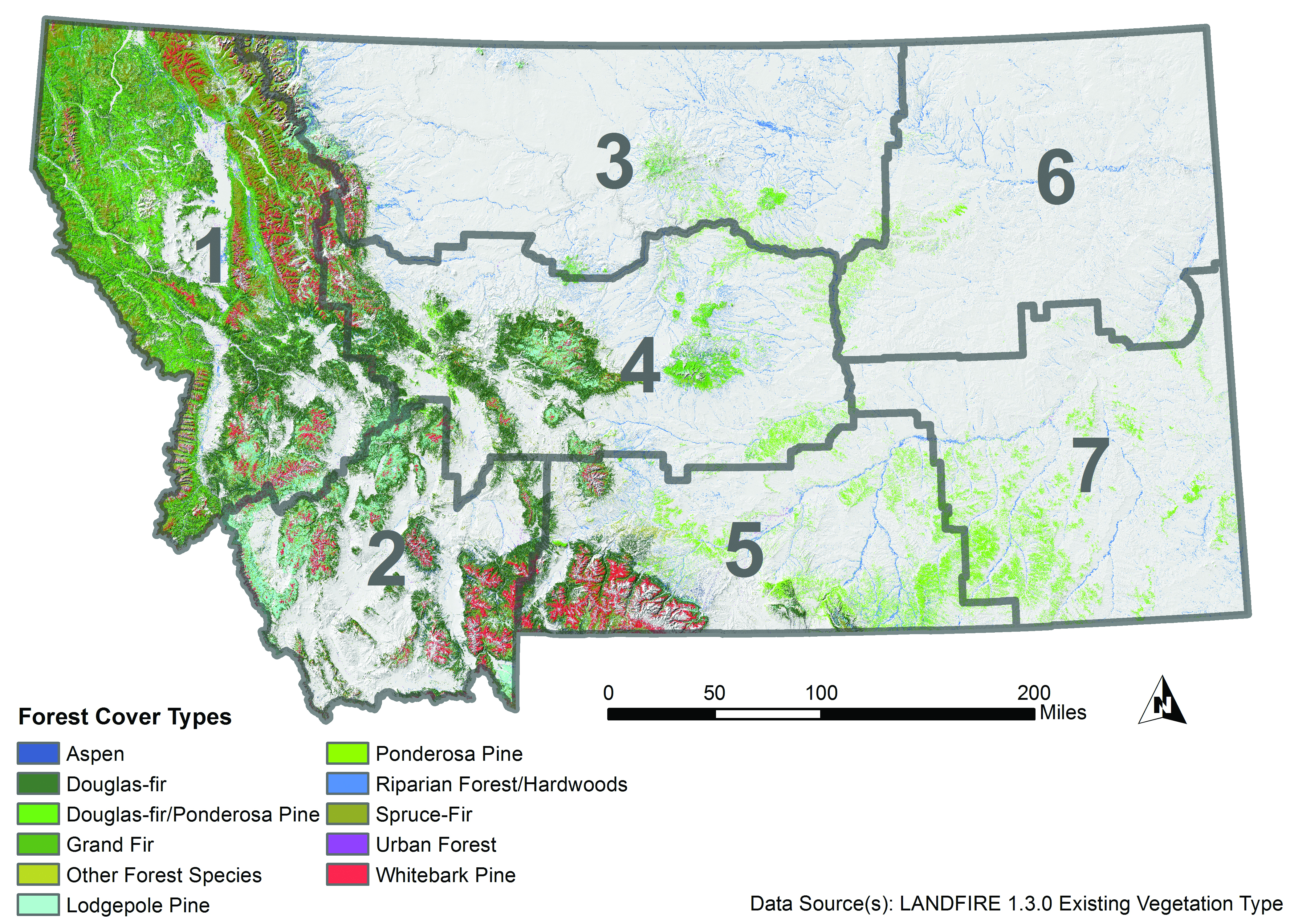
In the Forest chapter, we interpret how past and projected changes in climate—as described in the Climate chapter—may influence Montana forests. There are approximately 23 million acres (9.3 million ha) of forested land in Montana, and most are publicly owned, in the western part of the state and dominated by Douglas-fir, lodgepole pine, and ponderosa pine (Figure V). Forest conditions in Montana are varied, and potential impacts from climate change will overlay on existing stresses to forests. Ultimately, forest managers will need to consider specific adaptation actions in response to current and potential climate changes.
|
|
| Figure V. Existing forest cover type in Montana (Landfire 2012). Gray boundaries delineate climate divisions (see Figure I). |
Our analysis
In the face of changing climate, forest managers can best maintain forest health and stable product yield by understanding past trends and planning for a range of climate scenarios. The analysis in the Forest chapter is based on the climate trends for which we had sufficient data and climate projections that represent plausible future scenarios, as described in the Climate chapter. It is important to note that current forest conditions will largely determine the potential impacts from current and future climate change. Forest conditions vary across land ownership types, and many Montana forests are under stress due to past forest management practices. In addition, we do not detail potential responses of individual tree species to climate shifts in this assessment; instead, we focus on the direct and indirect effects of climate change on forests. We point the reader to Chapter 6 in the Northern Region Assessment Program report (Keane et al. forthcoming) for species-level information.
Major findings
The direct effects of climate change on forests include increased temperatures and shifts in precipitation that together alter humidity, soil moisture, and water stress. Direct effects can be beneficial or detrimental to forest growth and survival. The results of this analysis on the direct effects of climate change on Montana’s forests produced several key messages, some of which are shown below (for a complete list of key messages, see the Forests chapter):
- Increased temperatures will have positive or negative effects on individual trees and forest-wide processes, depending on local site and stand conditions, but impacts from increased extreme heat will be negative. [high agreement, moderate evidence]
- Direct effects of climate change on individual trees will be driven by temperature in energy-limited forests and moisture in water-limited forests. [high agreement, moderate evidence]
- The speed and magnitude of climate change may mean that increased forest mortality and contractions in forest distribution will outpace any gains in forest growth and productivity over the long run, leading to a net loss of forested area in Montana. [medium agreement, limited evidence]
| Direct effect | Possible impacts | Projected net effect |
| Establishment and regeneration | Positive: Higher CO2 concentrations and temperatures may lead to increased tree fecundity Negative: Higher temperatures and reduced water availability could reduce seedling survival |
Possible positive or negative effects are superimposed on climate oscillations, such as the Pacific Decadal Oscillation, which can produce decades of cooler and wetter conditions that may be more favorable for establishment and regeneration |
| Growth and productivity | Positive: Increased vegetation water use and increased growth and productivity as a result of longer growing season Negative: Reduced growth and productivity in water limited areas |
Possible increased growth and productivity concurrent with climate oscillations that increase water availability, particularly at higher elevations and where stand density is low; extreme high temperatures would have net negative impact, regardless of water availability |
| Mortality | Positive: Few opportunities for reduced direct climate effects on mortality but possibility for reduced mortality from indirect effects Negative: Increased acute and background mortality from increased temperatures and indirectly from increased disturbance |
Increased mortality, although may be driven by indirect effects; patterns of mortality will be dependent on initial stand and local site conditions, but more arid regions more susceptible |
| Range shifts and forest distribution | Positive: Potential range expansion with warmer temperatures and sufficient moisture Negative: Potential range contraction where temperature is too high or in water-limited locations |
Possible faster range contraction compared to expansion, with net range reduction particularly in drier areas; no clear direction of elevational shifts; responses will be highly species and location dependent |
Indirect effects of climate change on forests include disturbance—a key component of forest ecology—and may be more important, immediate, and longer lasting than direct effects. As with direct effects, indirect effects can compound existing forest conditions and impacts from past and future human land-use activities (Moritz and Agudo 2013).
The results of this analysis on the indirect effects of climate change on Montana’s forests produced several key messages, some of which are shown below (for a complete list of key messages, see the Forests chapter):
An increase in fire risk (i.e., probability of occurrence)—including an increase in size and possible frequency and/or severity (i.e., tree mortality)—is expected in the coming century as a result of a) prolonged fire seasons due to increased temperatures, and b) increased fuel loads from past fire suppression. [high agreement, robust evidence]
Rising temperatures are likely to increase bark beetle survival [high agreement, strong evidence], but climate-induced changes to other insects and forest pathogens are more varied and less certain [medium agreement, moderate evidence]
There may be a reduction in the amount of carbon stored in forests. [low agreement, limited evidence]
Table III provides a summary of potential climate-related indirect effects to forests.
| Indirect effect | Possible impacts | Projected net effect |
| Disturbance: fire | Positive: Increased forest heterogeneity (long-term, post-burn) Negative: Decreased forest diversity and heterogeneity (immediately post-burn); increased social and economic impacts from fire; increased release of forest carbon | Increased fire severity resulting primarily from warmer weather and past fire suppression; increased release of forest carbon from fire |
| Disturbance: pathogens | Positive: Some pathogen species may decline and result in decreased forest mortality Negative: Some pathogens species may increase and result in increased forest mortality and increased susceptibility to beetle attack | Uncertain climate effects on pathogens, dependent on moisture regimes, pathogen species, and host species |
| Disturbance: insects | Negative: Increased forest mortality; reduced forest diversity with shift towards non-host tree species | Increased temperatures likely to result in increased insect disturbance, but dependent on elevation, insect species and host availability |
| Soil responses and carbon storage | Positive: Increased organic matter if increased productivity; increased nitrogen availability Negative: Decreased organic matter (with increased decomposition rates); decreased mycorrhizal support; increased soil acidity; increased release, or decreased removal, of atmospheric CO2 | Uncertain climate effects on soil responses, but projected reductions in soil and forest carbon storage |
IMPACTS TO MONTANA’S AGRICULTURE
Agriculture in Montana
Agriculture is a key industry in Montana, generating over $5.2 billion in 2014 through the sale of agricultural commodities (USDA-NASS 2015). Montana’s large agricultural industry consists of both crops and livestock. Montana’s farm and ranchland support a mosaic of dryland and irrigated agriculture, commodity and specialty cropland, and native and planted rangeland. Although more Montanans live in cities than on farms and ranches, we think of Montana as an agricultural state, where the non-forested landscape is dominated by livestock and crop production.
Our analysis
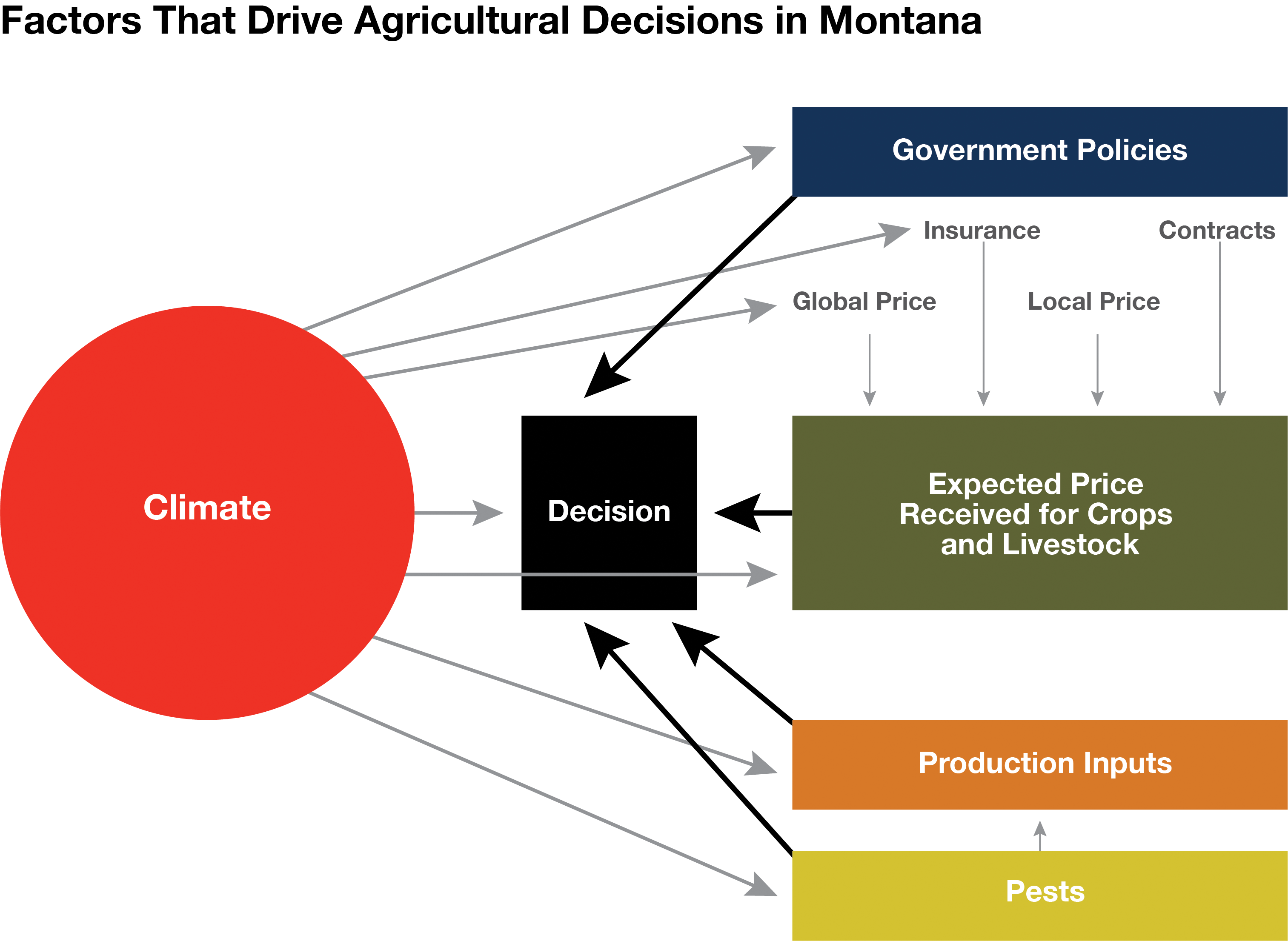
Montana agriculture has always faced volatility, extreme events, and variability across the state and these conditions will continue to be the case with projected climate changes in Montana. Climate model projections show a warmer Montana in the future, with mixed changes in precipitation, more extreme events, and mixed certainty about upcoming drought. The Agriculture chapter examines potential impacts of projected climate change on commodity crops, livestock, pollinators, disease, pests, and weeds. However, any effort at assessing climate impacts on agriculture faces multiple levels of uncertainty, including uncertainty that a) accompanies all climate projections, b) is specific to agricultural projections, and c) is created by adaptive actions (human interventions) that can mask a direct climate signal. Climate impacts on agriculture in other regions of the world can also create uncertainty and have a major impact on Montana agriculture by changing commodity prices and input costs. Increasing uncertainty due to complex interactions, whether through volatility or new and hard-to-predict temperature and moisture trends, can disrupt agricultural decision-making and will probably become an even more important direct agriculture decision-driver in the years ahead (See Figure VI).
|
|
| Figure VI. Factors that drive agricultural decisions in Montana. The size of bubble and arrows qualitatively represents the relative importance of each factor’s influence on agricultural production decisions. |
Major findings
The results of this analysis produced several key messages, some of which are shown below, about how climate change will affect Montana agriculture (for a complete list of key messages, see the Agriculture chapter):
- Every component of agriculture—from prices to plant pollinators and crop pests—exhibits complex relationships to climate, depending on the location, weather variability, and agricultural and economic practices and policies (Figure VI). Social and economic resilience to withstand and adapt to variable conditions has always been a hallmark of Montana farmers’ and livestock producers’ strategies for coping with climate variability. [high agreement, robust evidence]
- Decreasing mountain snowpack will continue to lead to decreased streamflow and less reliable irrigation capacity during the late growing season. Reduced irrigation capacity will have the greatest impact on hay, sugar beet, malt barley, market garden, and potato production across the state. [high agreement, robust evidence]
- Increases in temperature will allow winter annual weeds, such as cheatgrass, to increase in distribution and frequency in winter wheat cropland and rangeland. Their spread will result in decreased crop yields and forage productivity as well as increased rangeland wildfire frequency. [high agreement, medium evidence]
- Climate change affects global-price-determined commodity agriculture differently than it affects non-commodity agriculture. Commodity crops, such as small grains, are more directly driven by global markets and agricultural subsidies, whereas non-commodity crops tend to be more directly tied to local or specialized non-local markets and local micro-climates. [high agreement, medium evidence]
- Diversified cropping systems, including rotation with pulse crops and innovations in tillage and cover-cropping, along with other measures to improve soil health, will continue to allow adaptation to climate change. [medium agreement, low evidence]
CONCLUSIONS
The 2017 Montana Climate Assessment focused on three sectors that Montana stakeholders identified as important to their lives: water, forests, and agriculture. The MCA found that all three of these sectors have experienced impacts from climate change over the last half century. In addition to exploring how the past climate has changed and its effects on Montana, the MCA explored how future projected climate change would also affect water, forests, and agriculture across the state. The overall objective of the MCA is to inform Montanans about the state’s changing climate so that they can better plan for the future.
LITERATURE CITED
Forster P, Ramaswamy V, Artaxo P, Berntsen T, Betts R, Fahey DW, Haywood J, and 45 more. 2007. Changes in atmospheric constituents and in radiative forcing [chapter]. In: Solomon S, Qin D, Manning M, Chen Z, Marquis M, Averyt KB, Tignor M, Miller HL, editors. Climate change 2007: the physical science basis. Cambridge UK: Cambridge University Press. p 129-234.
Keane RE, Mahalovich MF, Bollenbacher B, Manning M, Loehman R, Jain T, Holsinger LM, Larson A, Grahman R, Webster M. [forthcoming]. Forest vegetation [chapter]. Northern Rockies vulnerability assessment and adaptation plan (NRAP). Fort Collins CO: USDA Forest Service, Rocky Mountain Research Station. Report # RMRS-GTR-xxx.
Landfire. 2012. Existing vegetation cover data v1.3.0 [website]. Available online https://www.landfire.gov/index.php#. Accessed 2017 May 10.
Moritz C, Agudo R. 2013. The future of species under climate change: resilience or decline? Science 341:504–8.
[MT DNRC] Montana Department of Natural Resources and Conservation. 2014a. Clark Fork and Kootenai River basins, water plan 2014. Helena MT: State of Montana, DNRC. 167 p. Available online http://dnrc.mt.gov/divisions/water/management/docs/state-water-plan/clar.... Accessed 2017 May 8.
[MT DNRC] Montana Department of Natural Resources and Conservation. 2014b. Lower Missouri River basin, water plan 2014. Helena MT: State of Montana, DNRC. 191 p. Available online http://dnrc.mt.gov/divisions/water/management/docs/state-water-plan/lowe.... Accessed 2017 May 8.
[MT DNRC] Montana Department of Natural Resources and Conservation. 2014c. Upper Missouri River basin, water plan 2014. Helena MT: State of Montana, DNRC. 219 p. Available online http://dnrc.mt.gov/divisions/water/management/docs/state-water-plan/uppe.... Accessed 2017 May 8.
[MT DNRC] Montana Department of Natural Resources and Conservation. 2014d. Yellowstone River basin, water plan 2014. Helena MT: State of Montana, DNRC. 186 p. Available online http://dnrc.mt.gov/divisions/water/management/docs/state-water-plan/yell.... Accessed 2017 May 9.
[MT DNRC] Montana Department of Natural Resources and Conservation. 2015. Montana State Water Plan: a watershed approach to the 2015 Montana state water plan. Helena MT: State of Montana, DNRC. 84 p. Available online http://dnrc.mt.gov/divisions/water/management/docs/state-water-plan/2015.... Accessed 2017 Mar 6.
[NOAA] National Oceanic and Atmospheric Administration. [undated]. US climate divisions [website]. Available online https://www.ncdc.noaa.gov/monitoring-references/maps/us-climate-division.... Accessed 2017 Mar 6.
[USDA-NASS] US Department of Agriculture—National Agricultural Statistics Service. 2015. National Agricultural Statistics Service [website]. Available online https://www.nass.usda.gov. Accessed 2017 May 9.
[USGCRP] US Global Change Research Program. [undated]. Glossary [website]. Available online http://www.globalchange.gov/climate-change/glossary. Accessed 2017 Mar 6.